
将多个自动气象站架设到8000米以上海拔|“巅峰使命”珠峰科考活动全面启动
【自动对焦:气象自动化】科考队还计划创造多项科学考察研究的世界纪录,包括联合西藏登山队,将多个自动气象站架设到8000米以上海拔,实现珠峰极高海拔区气象梯度自动观测和数据传输;首次在地球之巅利用高精度雷达测量冰雪厚度;尝试突破浮空艇大气观测海拔世界纪录,到达9000米;本次科考还将追踪极高海拔大气污染的输送及科考人员的高海拔适应性。
西藏 “巅峰使命”珠峰科考今日全面启动
记者从第二次青藏高原综合科学考察研究队获悉,“巅峰使命”珠峰科考活动今天(4月28日)全面启动,总台记者全程跟踪报道,带你走进“巅峰使命”珠峰科考现场。
第二次青藏科考队队长姚檀栋院士介绍,此次珠峰科考将首次应用先进技术、方法和手段,围绕西风-季风协同作用、亚洲水塔变化、生态系统与生物多样性、人类活动等重大科学问题,协同考察研究珠峰地区六大圈层的垂直变化特征和相互作用机理,揭秘气候变暖背景下珠峰极高海拔区环境变化规律、温室气体浓度变化特征及生态系统碳汇功能、人类对极端环境的适应特征,实现地球系统科学研究的新突破,提出珠峰自然保护创新科学方案。
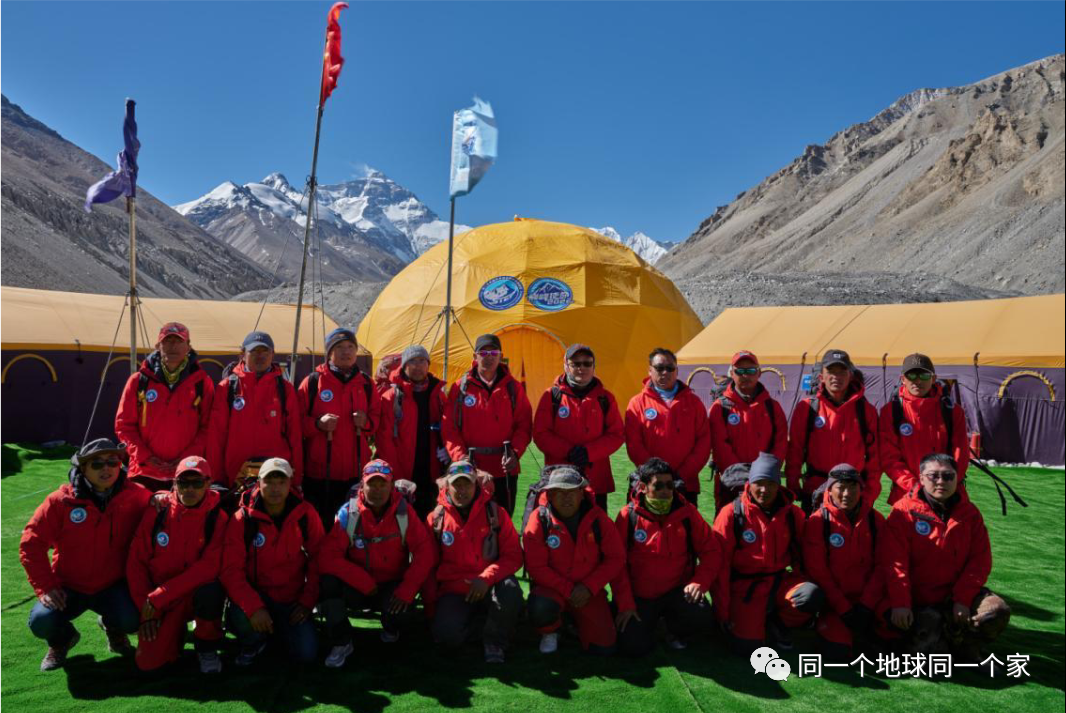
第二次青藏科考队联合西藏登山队实施此次珠峰科考。本次科考组织了西风-季风协同作用、亚洲水塔变化、生态系统与生物多样性、人类活动变化、地球动力学勘测等5支科考分队的16个科考小组共270余名科考队员参加,是第二次青藏科考自2017年启动以来学科覆盖面最广、参加科考队员最多、采用的仪器设备最先进的综合性科考。
科考队还计划创造多项科学考察研究的世界纪录,包括联合西藏登山队,将多个自动气象站架设到8000米以上海拔,实现珠峰极高海拔区气象梯度自动观测和数据传输;首次在地球之巅利用高精度雷达测量冰雪厚度;尝试突破浮空艇大气观测海拔世界纪录,到达9000米;本次科考还将追踪极高海拔大气污染的输送及科考人员的高海拔适应性。
据了解,我国自20世纪50年代起开展了超过6次的珠峰科考活动,此次组织开展的珠峰极高海拔地区综合科考将首次突破8000米以上海拔高度并完成珠峰峰顶的综合科学考察任务,是人类在珠峰地区开展极高海拔综合科学考察研究的一次壮举。
Tibet's "peak mission" Everest scientific research was fully launched todayThe reporter learned from the second Qinghai Tibet Plateau comprehensive scientific investigation and research team that the "peak mission" Everest scientific research activity was fully launched today (April 28). The head office reporter tracked and reported the whole process and took you to the "peak mission" Everest scientific research site.Academician Yao Tandong, the leader of the second Qinghai Tibet scientific research team, introduced that the scientific research on Everest will apply advanced technologies, methods and means for the first time to jointly investigate and study the vertical change characteristics and interaction mechanism of the six circles in the Everest region around major scientific issues such as the synergy of westerly monsoon, the change of Asian water tower, ecosystem and biodiversity, human activities and so on, so as to reveal the law of environmental change in the extremely high altitude area of Everest under the background of climate warming The change characteristics of greenhouse gas concentration, the carbon sink function of ecosystem and the adaptation characteristics of human beings to extreme environment, realize the new breakthrough in the scientific research of earth system, and put forward the innovative scientific scheme of Everest nature protection.The second Qinghai Tibet scientific research team and the Tibetan mountaineering team carried out the scientific research on Everest. More than 270 scientific research team members from 16 scientific research teams of 5 scientific research teams, including westerly monsoon synergy, Asian water tower change, ecosystem and biodiversity, human activity change and geodynamic survey, participated in this scientific research. It is a comprehensive scientific research with the widest subject coverage, the largest number of scientific research team members and the most advanced instruments and equipment since the second Qinghai Tibet scientific research was launched in 2017.The scientific research team also plans to set a number of world records for scientific investigation and research, including the joint Tibetan mountaineering team to set up multiple automatic weather stations at an altitude of more than 8000 meters, so as to realize the automatic observation and data transmission of meteorological gradient in the extremely high altitude area of Everest; It is the first time to use high-precision radar to measure the thickness of ice and snow on the top of the earth; Try to break the world record of atmospheric observation altitude of floating craft, reaching 9000 meters; This scientific research will also track the transportation of air pollution at very high altitude and the adaptability of scientific researchers at high altitude.It is understood that China has carried out more than six scientific research activities on Mount Everest since the 1950s. The comprehensive scientific research on the high altitude area of Mount Everest organized and carried out this time will break through the altitude of more than 8000 meters for the first time and complete the comprehensive scientific investigation task of the top of Mount Everest. It is a feat for human beings to carry out comprehensive scientific investigation and Research on the high altitude area of Mount Everest.
全球海拔最高的自动气象站
央视网消息:青藏高原是世界屋脊、亚洲水塔,被称为地球第三极,是我国重要的生态安全屏障。今天(4月28日),“巅峰使命”珠峰科考全面启动,16支科考小组270多名科考队员参加。这是自2017年第二次青藏科考以来,学科覆盖面最广、参加科考队员最多、采用的仪器设备最先进的综合性科考。
这次珠峰科考将聚焦珠峰地区的环境变化,从大气、水、生态、地表过程等方面进行全方位的考察。同时,还将围绕西风—季风协同作用等重大科学问题进行考察。
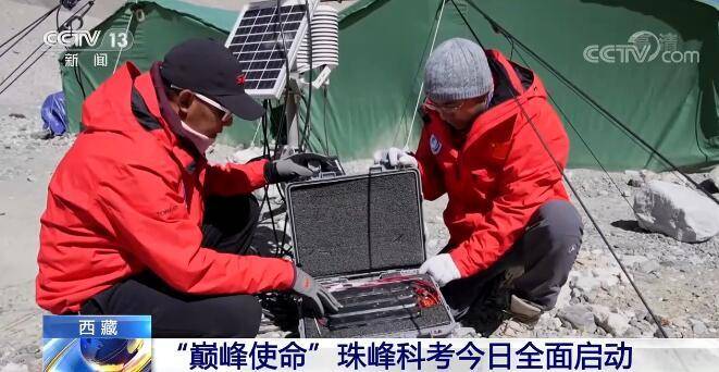
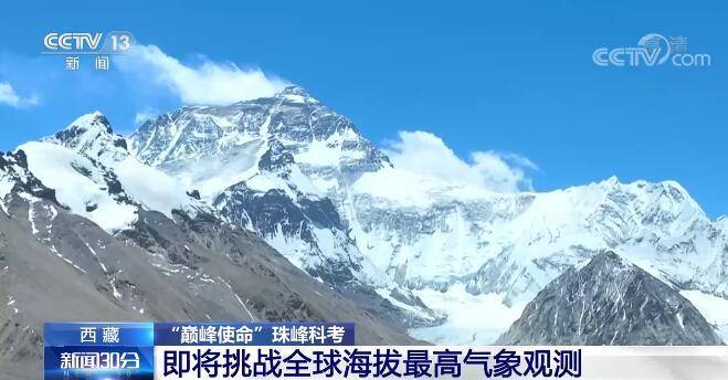
本轮珠峰科考中有一个重要的使命,就是要从海拔5200米到8800米搭建8个气象站,其中4个都在海拔7000米以上。而8800米的气象站架设成功后,将是全球海拔最高的自动气象站。
2022年4月20日,14名科考登山队员克服8级大风和极度缺氧的困难,在海拔7790米架设了一架极高海拔的自动气象站,创下中国自动气象站架设最高海拔纪录。
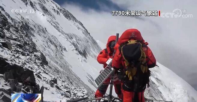
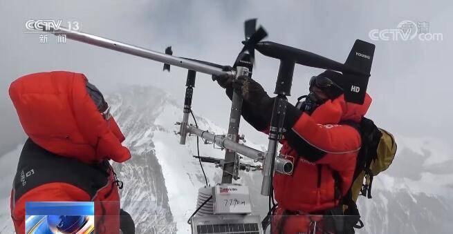
6个小时后,14名科考队员在8300米成功架设了同类型的自动气象站,再次刷新了我国自动气象站的海拔纪录。
虽然8300米的自动气象站总重是50公斤,比在低海拔的常规气象站轻20公斤,但光是要把这些气象站设备运到8300米就是一件难事。
“巅峰使命”珠峰科考登顶科考小组副组长 扎西平措:有些是易碎品,然后再保护起来,保护到自己背上去,有些不是易碎品的都是牦牛驮到6500米处,从6500米往上都是我们人工运上去。
中国科学院青藏高原研究所研究员 赵华标:我们现在高海拔是缺少这种气象观测的,像常规的气象观测一般都在5000米以下,5000米以上很少的。如果我们这次这个高度(8800米)架设成功之后,将是全球最高海拔的气象观测。
记者:我很好奇为什么是8800米,不是8848米?
赵华标:因为峰顶上是雪和冰,不太好固定,所以我们在8800米左右找个基岩的面上进行固定。
8个不同梯度的自动气象站主要是立体监测珠峰地区的气温、相对湿度、风向、风速、气压和辐射等参数变化,并且可以实现数据的实时远程传输。
赵华标:青藏高原是第三极,它的海拔很高,它的气温变化不同的海拔是不一样的,而且珠峰就是极高区域,这样我们研究这个区域的气温变化、梯度变化,这样可以对第三极整个地区的气温还有海拔变化就会有了解。


")


——基于碳化硅中硅空位色心的高压原位磁探测")


评论排行